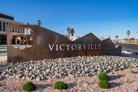
Victorville
Victorville is a city located in the Victor Valley of San Bernardino County, California. The city of Victorville was officially incorporated by the State of California on September 21, 1962.
History
In 1858, Aaron G. Lane came to what is now known as Victorville and founded a way station called “Lane’s Crossing.” For many years it provided shelter and supplies for people making the journey across the desert from the east to San Bernardino. Lane’s Crossing was on the Mojave River on today’s Turner Road, two miles north from where Interstate 15 crosses the river. Captain Lane was a veteran of the Mexican–American War who had suffered from malaria during that war. Originally he migrated west to join the California gold rush, but he learned that he could make a better living selling supplies to the miners.
He settled in Ione, near Sutter’s Mill in northern California, during those years, but he migrated to San Bernardino in 1857. He settled on the Mojave River in 1858, where he established his way station. He later sold out to Texan John Fry Miller, who changed the name of Lane’s Crossing to Pioneer Station. Miller was a rancher and became involved in Mojave Valley politics, setting up the first polling place in the area at his home. That first year, ten citizens cast their votes at Lane’s residence, rather than making the long trip to San Bernardino.
Old Town Victorville
A controversial revitalization project started in 1995 in the ten square blocks along Historic Route 66. After years of setbacks in developing Old Town, the city—along with input from residents and local business owners—created an Old Town Strategic Action Plan in 2007. In 2008, demolition on hazardous and dilapidated buildings began. In 2010, as the economy declined, the statewide end of Economic Redevelopment Agencies, which funded the project, placed further work on indefinite hold. As of 2012, the area still had problems with crime and homelessness, and many buildings remain boarded up.
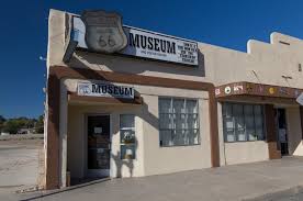
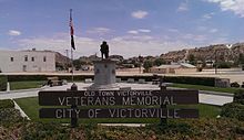
Projects include the Veteran’s Memorial on the corner of Seventh Street and Forrest Avenue, the Route 66 Museum, the Transportation Center, and the Old Victor School. Several large murals have been painted on the sides of buildings in Old Town
Geography
Victorville is located at the southwestern edge of the Mojave Desert, 81 miles northeast of Los Angeles, 148 miles north of San Diego, 188 miles southwest of Las Vegas, 32 miles south of Barstow, 48 miles east of Palmdale, and 36 miles north of San Bernardino through the Cajon Pass on Interstate 15. Victorville is the location of offices of the “Mojave Desert Branch” of the San Bernardino County government.
Victorville is bordered by Apple Valley on the east, Hesperia on the south, and Adelanto on the west. The Mojave River flows sporadically through Victorville. The elevation at City Hall is approximately 2,950 feet above sea level.